Network planning
Network planning is a feature of transport planning generally - roads, for example, are organised into a clear hierachy in order to ensure the efficient movement of vehicle traffic. Network planning is critical to an efficient public transport system and effective promotion of cycling. Yet walking has largely been taken for granted and has seldom been planned in the same methodical way.
In the context of walking, network planning considers origins and destinations to determine likely patterns of pedestrian movement and identify key routes. These routes can then be audited and improved to ensure that they provide for efficient, pleasant and convenient walking.
Principal Pedestrian Network (PPN)
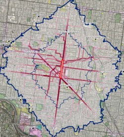 Camberwell walking demand heat map - Boroondara CC
The PPN methodology was developed by the Victorian Government to facilitate network planning for walking.
By identifying principal pedestrian routes, the PPN allows walking to be factored into VicRoads' Smart Roads system, which manages the relative priority of different transport modes through intersections on the arterial road network.
The PPN also provides an objective method of prioritising walking routes for infrastructure investment. Identified routes can be audited and improved to ensure that they provide for efficient, pleasant and convenient walking.
For detailed information on how to prepare a PPN, see the Guidelines for Developing Principal Pedestrian Networks, available from the Department of Economic Development, Jobs, Transport and Resources.
The PPN methodology was piloted through the PPN Demonstration Project, a collaboration between the Victorian Government, Victoria Walks, Melbourne University and four councils, half funded by the Federal Government through the Liveable Cities Program.
PPN Demonstration Project
 Communications material from the Lilydale PPN
The PPN Demonstration Project saw Boroondara, Frankston, and Geelong City Councils and Yarra Ranges Shire Council undertake PPN works.
The results have been excellent. In Camberwell, the City of Boroondara improved walking infrastructure and trialled two rounds of a ‘Try Walking’ promotion program. The second round, which focussed on the Camberwell Road Corridor, resulted in 1,100 additional pedestrians during a weekday (double previous numbers) and 375 additional pedestrians on a Saturday (triple previous numbers). It is estimated that there will be $6 in community health benefits over 30 years for every $1 spent.
In Lilydale, Yarra Ranges Shire Council's project involved construction of footpaths, crossings, wayfinding signage, rain gardens, street trading infrastructure and promotion programs (pictured on this page). Part of the project involved relocating a school crossing, which was in a 'safe' but slightly inconvenient location, so that less than half the students were using it. The crossing was moved to a roundabout on the pedestrian desire line and virtually everyone walking to the school now uses it.
The Lilydale project saw a 37% increase in walking for transport along one of the targeted routes. The Council was so happy with the project that they have decided to invest an extra $1.5 million per annum into new pedestrian infrastructure.
In the Frankston CBD, Park Lane and another pedestrian link received a full street upgrade to create a desirable place for pedestrians and local traders. New furniture, tree planting, art and lighting components enhanced the laneways between Wells Street and Young Street.
In Geelong, the City Council focused on Grovedale and Marshall, an area that was developed with some fairly poor infrastructure in the 1990s. The project saw the construction of key missing links in the footpath network, as well as street lighting, signage, tree planting and rest points.
More information on the projects is available from the Department of Economic Development, Jobs, Transport and Resources.
In addition to those involved in the Demonstration Project, a number of other councils including Manningham, Maroondah and Port Phillip have recently undertaken or are currently working on network planning for walking.